Weather Radar and Boaters
All Boaters need to understand weather radar.
In the old days, weather forecasters based their predictions on a combination of things:
2. Good eyesight (a weather eye); and
While today’s boater likely will look at his cell phone rather than looking up at the sky. For example, my wife can predict a change in weather by the pain in her elbow. She’s pretty accurate and she’s getting old too. (Note: I don’t let her read these.)
When dark clouds start building, having a basic understanding of how weather works can give you a head start on preparations.
Not all thunderstorms are intense, but they all are potentially dangerous. Boaters are especially vulnerable to the weather. They can’t simply run “inside” for protection. It pays to have basic weather-reading skills — so you can be prepared.
Here’s some help:
The Basics of Weather

Dark Clouds
Clouds
Whole books have been written on how to predict the weather by looking at clouds. Most people have a hard time remembering all the different types and what they signify. Here’s a simple rule of thumb: slow clouds get lower, or puffy clouds grow and get higher. Keep an eye out for rain or a storm. When looking at the sky, it’s helpful to remember that most weather changes come from the west. So keep your weather eye in that direction.
Generally, the slower the clouds change, the longer the duration of the weather change.
Thunderheads form quickly and dissipate just as quickly. Slowly thickening clouds associated with a cold front often mean a soaker.
Winds
Most of the time, winds are light in the morning. The winds pick up in the afternoon, and then return to light again as evening approaches.
If you find the wind speed not following the usual local pattern, suspect a change coming.
The direction of wind changes can also give you a heads-up to what’s coming. If the wind changes clockwise — say, from the south to southwest to the west — it usually means fair weather on the way.
If the wind changes counterclockwise, it usually signifies the approach of foul weather. An example would be, winds changing from the west to southwest and then to the south.
During the formation of a “pop-up” thunderstorm, the wind doesn’t always follow that rule. A “pop-up” thunderstorm often comes straight down from the clouds. It then spreads out in all directions. If you feel a sudden cool wind, check the sky for towering clouds.
Food for thought: When the speed of the wind increases, its effect on your boat rises exponentially. Your boat acts like a “sail.”
Did you know that a 20-knot wind has four times the force of a 10-knot wind?
Barometers
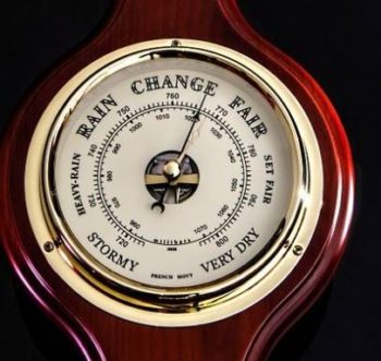
Weather Barometer
Barometers are more than just pretty brass instruments. The have a useful purpose. It’s just that most people do not understand their purpose – but they do look good.
Knowing what they’re saying can alert you to the advancing weather. Barometers are typically marked with areas of the face declaring “fair,” “changing,” and so on. The wording is misleading since reading a barometer is about noting changes.
A falling barometer usually means bad weather is approaching. It’s as much the speed of the change as the change itself that’s important to note.
A rapid fall means more significant changes. The normal pattern is a small up-and-down change that you can ignore.
A rapid rise may mean fair weather with strong winds. Typically, checking a barometer every couple of hours is adequate. Look for the direction of the change.
Thunder
If a thunderstorm is approaching, listening to thunder can tell you a lot about it. Counting the seconds between a “flash” of lightning and the “boom,” gives you the distance from the lightning. A five second difference equals about a mile.
Parents: if your children are afraid of thunder and lightning, explain that it is miles away. Then, distract them by asking them to count the seconds between the lightning and the thunder. It becomes a game for them, and they become less afraid of the noise.
Radar
Check the radar on your phone. Use the zip code 54301 for Green Bay. This is where the National Weather Service (NWS) is located. Their radar map includes the entire Door County peninsula.
The radar map will tell you where a storm is and where it’s heading. But, do not rely totally on radar. Because of the size of the Bay and Lake Michigan, there are frequently “pop-up” storms. That means unless you are actively looking at the radar, you can miss the approach of these storms.
Radar gives you the range and movement of the rain, allowing you to change course to avoid the worst. If the storm overtakes you – turn the boat “into” the waves and reduce speed.
Keep in mind, using the hourly radar will tell you where the rain is, but only a little information about the winds.
If you feel a sudden change in temperature, it signifies a change in wind intensity is coming. Start looking for a safe harbor, just in case.
Knowing the forecast before you head out is equally important.
BoatUS App
You can download and use the BoatUS App to track the weather. You’ll get small craft advisories and weather forecasts. Authorize “notifications” to receive updates about storm information. These occur each time NOAA tracks a storm heading your way.
NOAA
The most prominent weather data forecasts come from NOAA’s National Weather Service (NWS). NWS broadcasts weather for all parts of the U.S. via the Internet. It issues regular updated VHF broadcasts. All modern VHF radios can tune in to the forecasts, which operate on one of seven frequencies. Scan through the channels to find the best reception. Boaters can hear the computer-synthesized voice 25 miles or more from the transmitter.
The NOAA website lists current wind speed, wave height, and more at a nearby weather buoy. Go to: www.ndbc.noaa.gov for a look.
Weather Folk Lore
Red sky in morning, sailors take warning, red sky at night, sailors’ delight.

Pink Sky – Sailors Delight
Ever wonder what that means?
At night, a red sky signifies light passing through dust particles in the air in front of the setting sun. Dust indicates dry weather. Since most weather changes come from the west, a red sky at night means dry weather is approaching.
A red sky in the morning indicates that the dry air has moved east. Rain may be coming, especially if you see illuminated clouds.
If the morning sky is a deep fiery red, it means high water content in the atmosphere with the likelihood of rain. A gray sky at night means that the western air has a lot of moisture; therefore, it will likely rain soon.
One thing to remember: this rhyme can’t predict thunderstorms developing in the afternoon. Especially, when the morning has already been clear.
A summer fog for fair, a winter fog for rain.
Fog forms when the air cools enough that the water vapor condenses. When moist air moves over cold land, it will bring fog and possibly rain. For the air to be cool on a summer night, the sky must be clear. With clear skies, the excess heat can radiate into space. Cloudy skies act like a blanket, absorbing and re-radiating the heat, keeping it in.
If it is clear and cool enough for the fog to form on a summer morning, it should be clear later or at least by the next day.
When a halo rings the moon or sun, rain’s approaching on the run.
The halo around the sun or moon is caused by ice crystals high in the sky. A warm front is approaching and usually rain will be here within 24 hours. The rhyme is more accurate in the summer than the winter.
The higher the clouds, the better the weather.
High clouds mean both dry air and high atmospheric pressure. These indicate fair weather. Lower clouds mean approaching rain.
Marine Warnings and What They Mean
- Gale Warning: This is published when winds will be in the range of 34 to 47 knots.
- Storm Warning: This is issued if winds between 48 to 63 knots are forecast.
-
Special Marine Warning: This warning is for boaters, in particular. It is issued whenever a severe local storm or strong wind of brief duration is imminent. It is not covered by existing warnings or advisories.
To sum this up – Learn all you can about clouds and winds – It can mean the difference between a nice cruise and a disaster.
Where can I find Pier & Waterfront Solutions?
Pier & Waterfront Solutions, 7325 St. Hwy 57, is located 3 miles south of Sturgeon Bay. Go 1 mile PAST the intersection with County MM (heading north). Look on the right at the intersection of Idlewild Road and Hwy 57.
PWS is

Pier & Waterfront Solutions remains “open” year-round.
The Covid-19 virus is beginning to wane. We can only hope people will continue to get the vaccine to help slow this illness. We continue to conduct as much business as possible by email, text, or phone.
Site visits continue as usual. When making in-person contacts, we follow “social distancing” guidelines when possible.
PWS display yard – OPEN 24-7
Red Tag
PWS‘s display area is always open for you to examine at your leisure. All displays available for sale have a numbered, red tag on them. Want more information on something you saw in our yard? Please reference that number when you inquire.
PWS provides estimates by email to make the process faster, safer, and paperless.
Call, message, or email Jerry with any questions.

Jerry Englebert
Contact Jerry at 920-493-4404 for more information or use this link.