Rip-Rap – Door County
WILL RIP-RAP PROTECT MY SHORELINE?
Headline – Lake Michigan’s water level rose 2 inches in the final week of January alone. And – it’s still rising!
So what?
A 2-inch rise in water level doesn’t seem like a whole lot, But, did you know it takes 778.4 BILLION
(that’s Billion with a B) gallons of water to do that.
DID WE GET YOUR ATTENTION?
According to the U.S. Army Corps of Engineers, Detroit District:
“Lake Michigan-Huron is starting well above its 2019 starting levels. The 2019 levels were already at their highest in years. (The U.S. Army Corps of Engineers treat Lake Michigan-Huron as one body of water.)”
The rise in water levels placed Lake Michigan well above where it started last year. It’s fair to say that with this start, we will likely see worsening erosion in 2020.
Here’s a quote from the Army Corps of Engineers –
“The current water level for Lake Michigan-Huron is 581.69 feet. That is 3 inches higher than one month ago, 20 inches higher than where it was just a year ago and 39 inches higher than where the lake typically is in January!”
Put in simplest terms, Lake Michigan and the Bay of Green Bay are very high.
ARE WE AT RECORD LEVELS?
If the month ended on January 24th, the answer would be a resounding yes. The lake level is a whopping 5 inches above the record highest monthly average, observed in 1987!
The water not only filled the Great Lakes, but it also saturated wetlands and swamps in the watershed. Those areas have served as “sponges” to absorb the excess water in the past.
After a few wet seasons, those areas can’t hold any more water. Any rain or snow that falls now ends up pushing lake levels even higher.
When lake levels rise, the rivers and tributaries feeding the bay begin to swell with the excess water. The extra water means flooding in any low-lying areas. Remember -Those areas are also saturated.
The reality of the situation is that lakes Michigan and Huron are full. The lakes are beyond full. Don’t forget – Lake Superior is also at an all-time high.
The excess water means land that has been dry for decades is now wet. Soils that haven’t seen lake levels this high since 1986 are suddenly saturated.
THE SECOND FACTOR – WIND
The wind is the second-factor driving erosion of your shoreline.
If you have a 30 mile per hour wind (especially from the NW, in our case), on top of the high water, you get a three or 4-foot wave. The water begins to slam into the shorelines at a higher level, not seen since ’86. To make matters even worse, NE winds cause a surge in water depth.
In the past, the upper levels of your shoreline only saw waves during a few storms each year. Today, the waves are pounding the shores at much higher levels on a daily basis.
Wind-driven waves batter the shoreline – one wave after another, around the clock, day in and day out. There’s nothing unusual about continuous waves. Except, now they are battering much higher on the shoreline.
The record levels of water and strong gusty winds create a lot of energy in the form of wave action.
Rip-rap helps reduce the effects of the waves.
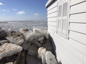
The waves scrub the shoreline and batter the substrate. Waves loosen the once stable and dry shore over time. Now, throw in the occasional storm, and the impact intensifies even more.
SAND BEACHES
If you have sand as your predominate substrate, the waves loosen it. Eventually, the substrate breaks down and moves with the waves. The water takes away a lot of the base that’s on your shore.
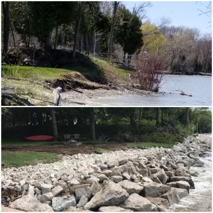
Someone once said, “A picture is worth a thousand words”. Well, here’s the picture – link. This is in Lower Michigan but the same thing is happening to the Door County peninsula shorelines. Note the protection from the rip-rap areas.
HIGH EMBANKMENTS
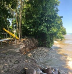
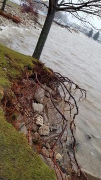
If you have a high embankment, the situation is similar to a sand beach. With higher water and saturated ground, the waves pound against the raised embankment. Only roots, weeds, and small rocks hold the soil in place.
Now wash away the soil from the embankment, and the roots can no longer hold the ground in place. The rocks become dislodged and wash away.
BEDROCK?
With high water levels, many people have no shoreline left. The waves continuously batter the bedrock walls. Every small piece dislodged from the bedrock exposes a new surface for the waves to attack.
Moisture gets into the small fissures, and the freeze-thaw cycle begins. The freeze-thaw cycle is widespread in early spring and late fall. Once the rock loosens, the waves can remove the pieces. It’s a natural cycle. Remember, the freeze-thaw period happens to roads every winter – they are called “potholes”.
WHEN WILL THIS STOP?
It will need a drop in lake levels before you don’t have to worry about losing your shoreline.
WHAT ABOUT THE WAVES?
Waves are the result of the friction between the water and winds. Mankind has no control over wind-driven waves. There is no way to control it.
Since we haven’t mastered the art of controlling rainfall or winds, there are limited things we can do to save our shorelines.
WHAT CAN YOU DO?
Since we can’t control the rain or the waves, experts say the best solution is either a seawall or rip-rap.
Seawalls are the more expensive option.
Rip-Rap is the alternative to a seawall. Rip-rap will reduce or eliminate the damage caused by high water and waves.
HOW DOES RIP-RAP WORK?
As waves move towards your shore, they absorb energy. When the waves get closer to shallow water, that energy causes the waves to rise and “curl”. This action generates turbulence at the leading edge.
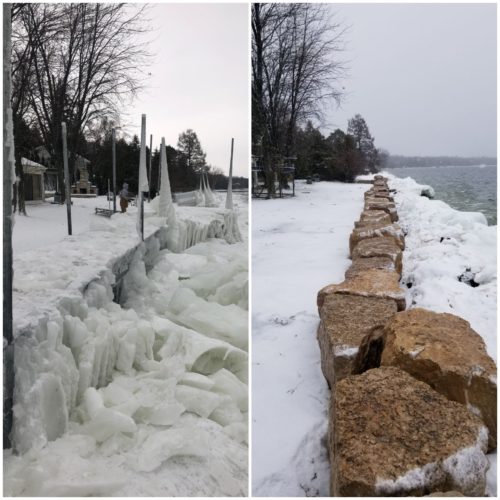
Rip-rap breaks the energy of the waves by absorbing and deflecting the power across the pile. We add a permeable barrier under the rip-rap to prevent the soil from washing out under it.
WILL RIP-RAP WASH AWAY?
A “toe stone” at the bottom of the rip-rap solves this problem. The “toe stone” consists of partially buried two-ton, up to 8 1/2 ton, boulder at the leading edge of the rip-rap. They help hold the rip-rap in place during wave action.
WHO DOES RIP-RAP IN DOOR COUNTY?
Pier & Waterfront Solutions (PWS) has installed many rip-rap installations to save properties like yours. Shouldn’t they be doing yours?
IS IT COST-EFFECTIVE?
Yes, Remember, your property values decrease if people see the shorelines washed out or if your lawn was carried away by the waves. First impressions are crucial to any sale.
WANT THE WORK DONE RIGHT?
PWS has dedicated teams who do nothing but rip-rap. Contact Dave @ (920) 905-2588 or Dave@wisconsinpws.com for your erosion control and shoreline work.
Tell Your Friends & Family
Have friends or neighbors you believe should see this article? Email them this link and – Thank you!
Don’t Forget
Pier & Waterfront Solutions (PWS) specializes in:
- ShoreMaster docks, lifts, and jet ski lifts;
- Lift Boss boat lift motors;
- Accessories for docks and lifts;
- Marina construction and repairs; Plus
NEW!! Shoreline erosion control and waterfront work
Visit Pier & Waterfront Solutions on Facebook also.
PWS is located at the intersection of Idlewild Road and Hwy 57. Located at 7325 St. Hwy 57. It’s 3 miles south of Sturgeon Bay, and 1 mile beyond the intersection of Cty MM (heading north).
Contact:
Dave @ (920) 905-2588 or Dave@wisconsinpws.com for erosion control and shoreline work.
Jerry @ (920) 493-4404 or Jerry@wisconsinpws.com for commercial work and new & used Sales.
John @ (920) 493- 4405 or John@wisconsinpws.com for Scheduling & Service work

